The Urban Hiker's Advantage
Asian cities sit next to mountains with a proximity that would be remarkable anywhere else but is treated as normal by residents who've spent their lives watching weather move across ridgelines visible from office windows. Hong Kong has more hiking trail per square kilometer than any major city on Earth. Seoul is flanked by Bukhansan National Park, where 836-meter granite peaks rise directly from the city's northern residential neighborhoods. Taipei is surrounded by mountains on three sides, with trailheads accessible by city bus. This proximity means that a serious hike—not a walk in a park but a trail with elevation gain, forest canopy, exposed ridgelines, and views that justify the effort—is accessible from downtown via public transit in most major Asian cities, often in under an hour. No car rental, no tour group, no elaborate planning. Just a metro ride, a trailhead, and the willingness to sweat.
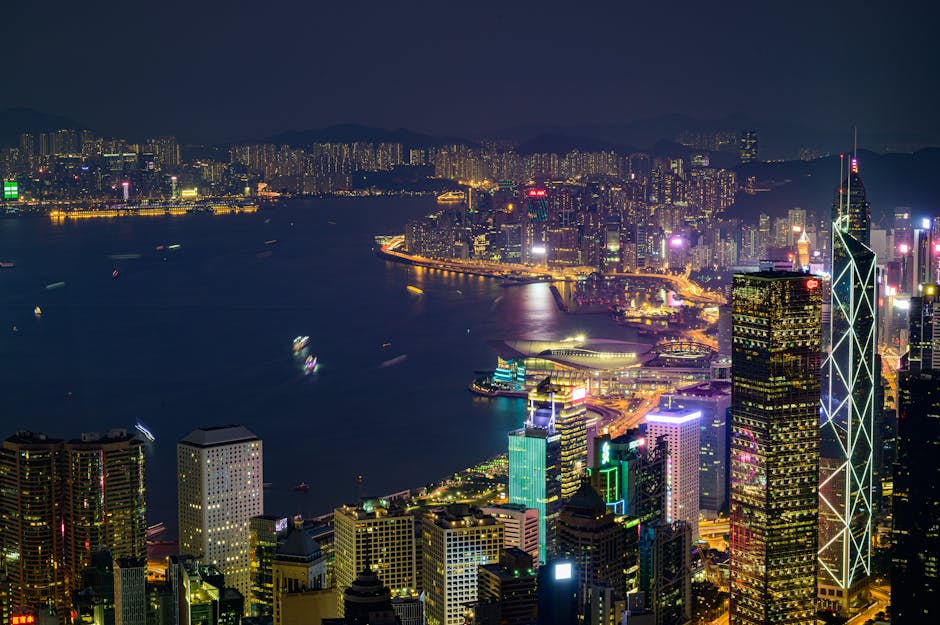
Hong Kong: Dragon's Back
Dragon's Back, on the southeastern tip of Hong Kong Island, is consistently ranked among the best urban hikes in Asia, and the reputation is earned. The trail runs 8.5 kilometers from Shek O Road to Big Wave Bay, following the undulating ridgeline that gives the hike its name—from certain angles, the succession of peaks and dips resembles a dragon's spine. The elevation gain is moderate (roughly 300 meters), the trail is well-maintained with clear signage, and the views—Shek O Beach below, the South China Sea stretching to the horizon, the city's towers visible to the northwest—reward every meter of ascent.
Access: Bus 9 from Shau Kei Wan MTR station to To Tei Wan (the trailhead stop), approximately 25 minutes. The hike takes 2.5-3.5 hours depending on pace and photo stops. The trail descends to Big Wave Bay, where a beach and a small cafe provide a satisfying endpoint. Return to the city via minibus 9 from Shek O to Shau Kei Wan MTR. The entire outing—including transit—fits comfortably into a half-day.
Seoul: Bukhansan Baegundae Peak
Bukhansan National Park's Baegundae Peak (836 meters) is the most popular summit hike in South Korea, drawing over 5 million hikers annually and providing views of the entire Seoul metropolitan area from a granite summit that feels impossibly wild given its proximity to a city of 10 million. The standard route from Bukhansanseong entrance takes 2.5-3 hours to ascend and 2 hours to descend, with the final section requiring scrambling over exposed granite using fixed steel cables and ropes. The effort is significant—this is a real mountain hike, not a walk—but the summit view, on clear days, extends from the DMZ in the north to the skyscrapers of Gangnam in the south, with the entire Han River basin visible between.
Access: Subway Line 3 to Gupabal station, then bus 704 to the park entrance, total transit time approximately 50 minutes from central Seoul. Hikers should start early (7-8 AM) to avoid the heaviest trail traffic and allow time for the round trip. Korean hiking culture involves significant preparation—hiking-specific clothing and boots, packed lunches, trekking poles, and the extensive selection of trail snacks (gimbap, fruit, rice cakes) that fuels the country's obsession with mountain climbing.
Inwangsan: The Easier Alternative
For a less demanding Seoul hike with equally impressive views, Inwangsan (338 meters) offers a 2-hour loop trail that follows the old Seoul Fortress Wall along a granite ridgeline overlooking the city. The trail is accessible from Dongnimmun station (Line 3), the elevation gain is modest, and the fortress wall—original 14th-century construction in many sections—provides historical context that Bukhansan's pure-nature experience lacks. The sunset from Inwangsan's ridgeline, with Seoul's lights beginning to glow below the darkening sky, is one of the city's finest free experiences.
Taipei: Elephant Mountain and Beyond
Xiangshan (Elephant Mountain) is Taipei's most accessible urban hike: a 20-minute climb from Xiangshan MRT station (the last stop on the Red Line) to a viewpoint that provides the iconic Taipei 101 skyline photograph. The trail is essentially a staircase—roughly 500 steps cut into the rock—and the summit rewards the brief effort with one of Asia's great urban panoramas: Taipei 101 in the foreground, the Da'an and Xinyi districts spread below, and the mountains of Yangmingshan visible to the north on clear days. The hike's brevity (30 minutes up, 20 minutes down) makes it ideal for sunset viewing—arrive 45 minutes before sunset, climb to the viewpoint, and watch the city transition from daylight to neon in real time.
For a longer Taipei hike, the Yangmingshan trails north of the city offer full-day options accessible by bus from Jiantan MRT station. The Seven Star Mountain trail (Qixingshan, 1,120 meters—Taipei's highest peak) takes 3-4 hours round trip and passes through volcanic landscapes including fumaroles, sulfur deposits, and hot springs. The Mt. Datun trail system provides gentler alternatives with grassland ridgelines and panoramic views of the Taipei basin. Both are reachable by public bus in under an hour from central Taipei.
Tokyo: Mount Takao
Takao-san (599 meters), 50 minutes from Shinjuku by Keio Line to Takaosanguchi station, is Tokyo's most accessible mountain and draws over 3 million hikers annually—more than Mount Fuji. The mountain offers six numbered trails of varying difficulty, from Trail 1 (paved, gentle, accessible to children and elderly hikers) to Trail 6 (a stream-following route that involves water crossings and moderate scrambling). The summit provides Mount Fuji views on clear days, and the descent on the opposite side (Trail 6 down to the Iroha Falls trailhead) extends the hike to roughly 4 hours for a satisfying full-morning outing.
Takao's secret weapon is the soba. The summit area has several soba (buckwheat noodle) restaurants, and eating a bowl of hot tororo soba (buckwheat noodles with grated mountain yam) for ¥1,000 after a morning hike, with Mount Fuji floating above the horizon, is a Tokyo experience that rivals any Michelin-starred meal for pure satisfaction. The cable car (¥490 one way) provides an alternative to hiking the lower section of Trail 1, useful for conserving energy for the upper trails or for making the mountain accessible to hikers with limited fitness.
The Universal Advice
Across all Asian city hikes: start early to avoid heat and crowds, carry more water than you think you need (1.5 liters minimum for any hike over 2 hours in tropical or subtropical climates), wear proper footwear (the trails described here range from paved to rocky, and flip-flops are never appropriate), and check the weather—tropical rain, summer heat, and winter wind can all transform a pleasant hike into a miserable or dangerous one. The trails are there, the views are spectacular, and the metro can get you to the start. Everything else is just putting one foot in front of the other.